How Drone Technology from Smart Farming NI is Helping Farmers Across Northern Ireland Save Time, Reduce Costs and Make Better Decisions June 2026
Farming has always been about making the right decisions at the right time.
But modern farming is becoming more challenging. Rising costs, larger land areas, unpredictable weather and tighter margins mean farmers need better ways to monitor their land, livestock and infrastructure.
This is where drone technology is starting to make a real difference.
Across Northern Ireland, more farmers are beginning to see how drones can save time, reduce unnecessary labour and provide valuable aerial information that would otherwise take hours or even days to gather.
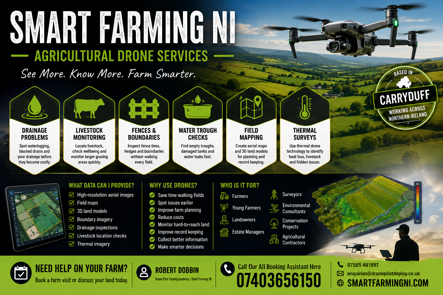
At Smart Farming NI, we are helping farmers use practical drone technology to inspect land, monitor livestock and identify problems earlier.
Spot Problems Before They Become Expensive
One of the biggest advantages of drones is speed.
A drone can inspect fields, fences, troughs and land conditions in minutes instead of hours.
This means issues like:
- blocked drains
- waterlogged ground
- damaged fencing
- leaking troughs
- missing livestock
can often be identified much earlier.
Finding these problems early can save both time and money.
Livestock Monitoring Made Easier
Checking livestock across larger fields or difficult terrain can take time, especially during poor weather or lambing season.
Drone surveys can help quickly locate cattle or sheep, monitor grazing areas and identify any unusual activity from above.
This is not about replacing good stockmanship — it is about adding another tool to make farm management easier.
Better Drainage and Land Management
Drainage issues are one of the most common hidden problems on farms.
Standing water, blocked drains and poor runoff can affect crops, grazing and machinery access.
Aerial drone imagery can help highlight problem areas faster and give farmers a better view of how water is moving across the land.
This can improve planning for future drainage work.
Mapping Fields and Boundaries
Drone mapping can provide:
- high-resolution aerial images
- field maps
- boundary records
- 3D land models
These can be useful for:
- land planning
- boundary reviews
- environmental work
- contractor discussions
- future development projects
Having accurate aerial records can be a valuable management tool.
Thermal Drone Surveys
Thermal technology adds another level of insight.
Thermal drone surveys can help with:
- livestock location
- heat loss
- hidden water leaks
- identifying unseen issues
This can be especially useful in low light, poor visibility or larger grazing areas.
Practical Drone Services for Northern Ireland Farmers
At Smart Farming NI, based in Carryduff near Belfast, we provide practical drone services across Northern Ireland to support farmers, landowners and rural businesses.
Our focus is simple:
Save time. Spot issues early. Improve decision-making.
If you would like to learn more about how drone technology could support your farm, visit our Agricultural Drone Services Northern Ireland page or get in touch to discuss your land.
Book a farm visit today and see how aerial technology can support smarter farming.