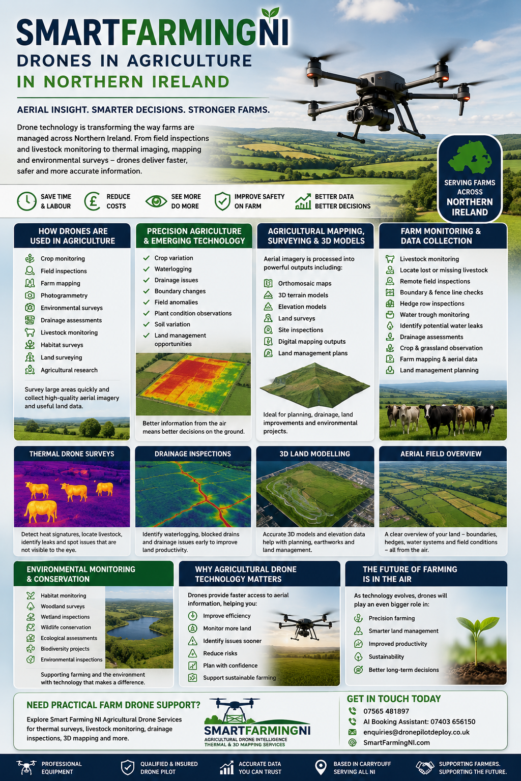

Smart Farming NI Drones in Agriculture in Northern Ireland
Drone technology is becoming an increasingly important part of modern agriculture across Northern Ireland, helping farmers, landowners and rural businesses improve how land is monitored, managed and understood.
From livestock checks and field inspections to thermal imaging, mapping and environmental monitoring, agricultural drones are creating new opportunities to collect valuable aerial information faster and more efficiently.
As farming continues to evolve, drones are helping bridge the gap between traditional farming methods and emerging agricultural technology.
How Drones Are Used in Agriculture
Agricultural drones are now being used worldwide to support:
- Crop monitoring
- Field inspections
- Farm mapping
- Photogrammetry
- Environmental surveys
- Drainage observations
- Livestock monitoring
- Habitat surveys
- Land inspections
- Agricultural research
Drone technology allows large areas of land to be reviewed quickly while collecting high-quality aerial imagery and useful land data.
Precision Agriculture and Emerging Farm Technology
Precision agriculture is helping farmers make more informed decisions using technology and data.
Drones can provide detailed aerial overviews of farmland, helping identify:
- Crop variation
- Waterlogging
- Drainage issues
- Boundary changes
- Field anomalies
- Plant condition observations
- Soil variation
- Land management opportunities
Instead of relying solely on ground inspections, drone technology allows farmers and land managers to gain a broader understanding of land conditions.
As technology continues to develop, the role of drones within agriculture is expected to increase.
Agricultural Mapping, Surveying & 3D Land Models
Drone mapping is becoming an important tool for agricultural businesses.
Using specialist software, aerial imagery can be processed into:
- Orthomosaic maps
- 3D terrain models
- Elevation models
- Site inspections
- Digital mapping outputs
- Land management plans
These outputs can support agricultural planning, drainage awareness, environmental projects and future land improvements.
Farm Monitoring & Aerial Data Collection
Modern drone technology allows farmers and land managers to gather useful information across large areas of land quickly, safely and efficiently.
Across Northern Ireland, drones are increasingly being used for:
- Livestock monitoring
- Locating missing livestock
- Remote field inspections
- Boundary and fence line checks
- Hedge row inspections
- Water trough monitoring
- Identifying possible water leaks
- Drainage observations
- Crop and grassland observation
- Farm mapping and aerial land reviews
- Land management planning
Using aerial imagery and thermal data, drones can help highlight visible issues that may otherwise go unnoticed, particularly across larger farms and remote areas.
Rather than travelling field to field, drone technology can provide a faster aerial overview of livestock locations, boundary conditions, water systems and wider land conditions.
Environmental Monitoring & Conservation
Drone technology is not only supporting farming but also wider environmental and conservation work across Northern Ireland.
Applications include:
- Habitat monitoring
- Woodland surveys
- Wetland inspections
- Wildlife conservation
- Ecological observations
- Biodiversity projects
- Environmental inspections
Many of the same drone technologies used in agriculture can also support environmental projects and wider land management.
Why Agricultural Drone Technology Matters
Agricultural drone technology is becoming an increasingly important part of farming, land management and environmental monitoring.
Across Northern Ireland, drones are helping improve how land is observed, monitored and understood by providing faster access to aerial information.
From livestock location and drainage inspections to thermal imaging and 3D mapping, drone technology allows landowners and farmers to gain a broader view of their land and identify areas that may require closer inspection.
As farming continues to evolve, aerial intelligence and data collection are expected to play an increasingly important role in improving efficiency, supporting land planning and helping farmers make better-informed decisions.
Future Agricultural Drone Opportunities
The agricultural drone sector is continuing to grow.
Future opportunities may include:
- Agricultural surveying
- Farm mapping
- Crop observation
- Environmental monitoring
- Inspection services
- Land management
- Conservation projects
- Research and development
- Emerging smart farming technologies
As drone technology becomes more widely adopted, demand for aerial data collection and specialist drone services is expected to continue growing.
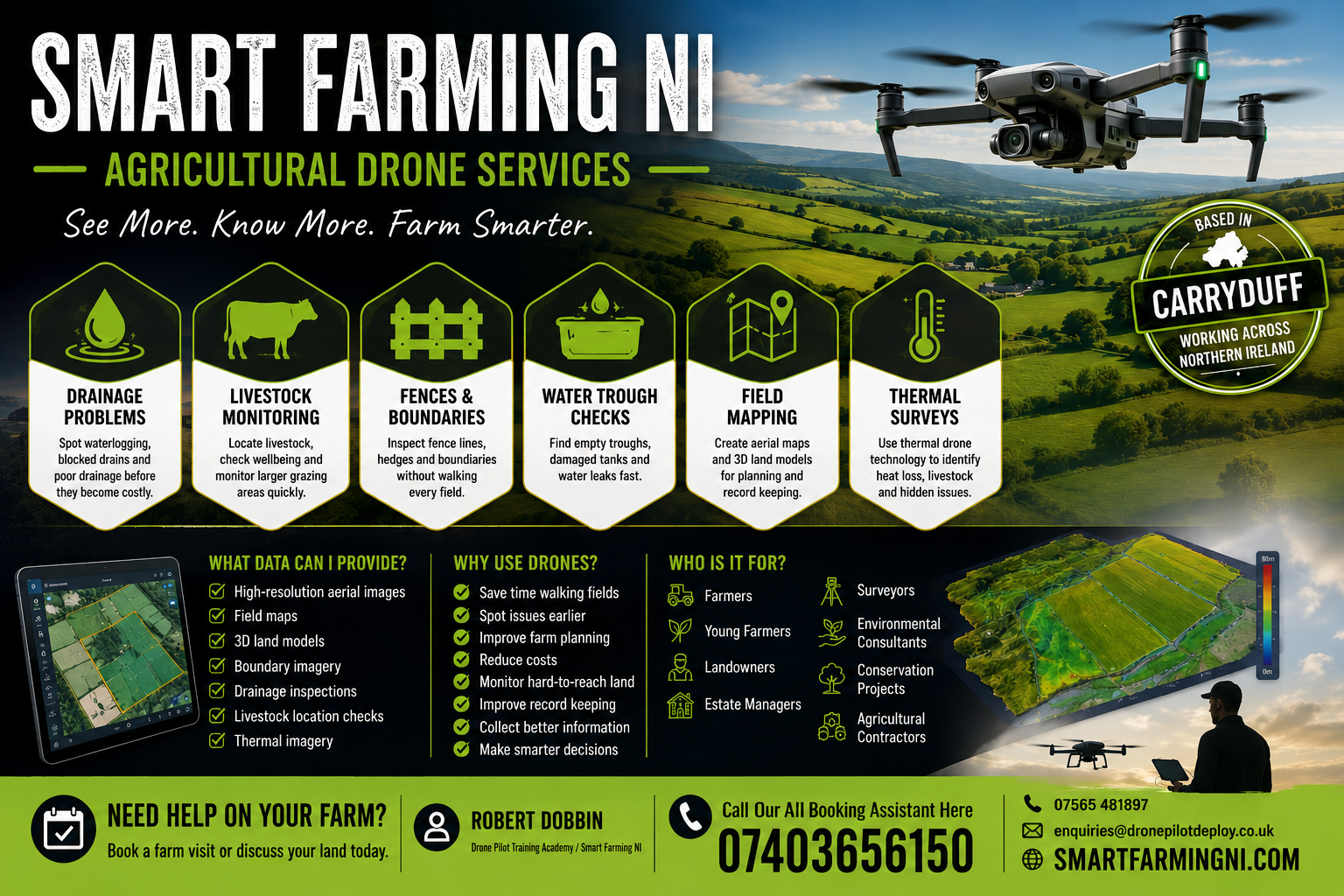
Learn More About Agricultural Drone Technology
As agricultural drone technology continues to grow, more farmers, landowners and rural businesses are exploring how drones can support land monitoring, mapping and wider farm management.
Whether your interest is practical farm support, aerial land intelligence or understanding future agricultural opportunities, drone technology is becoming an important part of modern farming.
If you would like to learn more about agricultural drone services, thermal surveys, livestock monitoring or farm mapping, explore our Smart Farming NI Agricultural Drone Services page.
Smart Farming NI
Robert Dobbin
Agricultural Drone Intelligence, Thermal & 3D Mapping Specialist
📱
07565 481897
📞
AI Booking Assistant: 07403 656150
📧
enquiries@dronepilotdeploy.co.uk
Get in touch today to learn more about agricultural drone technology in Northern Ireland.