Smart Farming NI | New Agricultural Drone Services in Northern Ireland July 2026
Drone technology is becoming an increasingly useful tool for farmers, landowners and rural businesses across Northern Ireland.
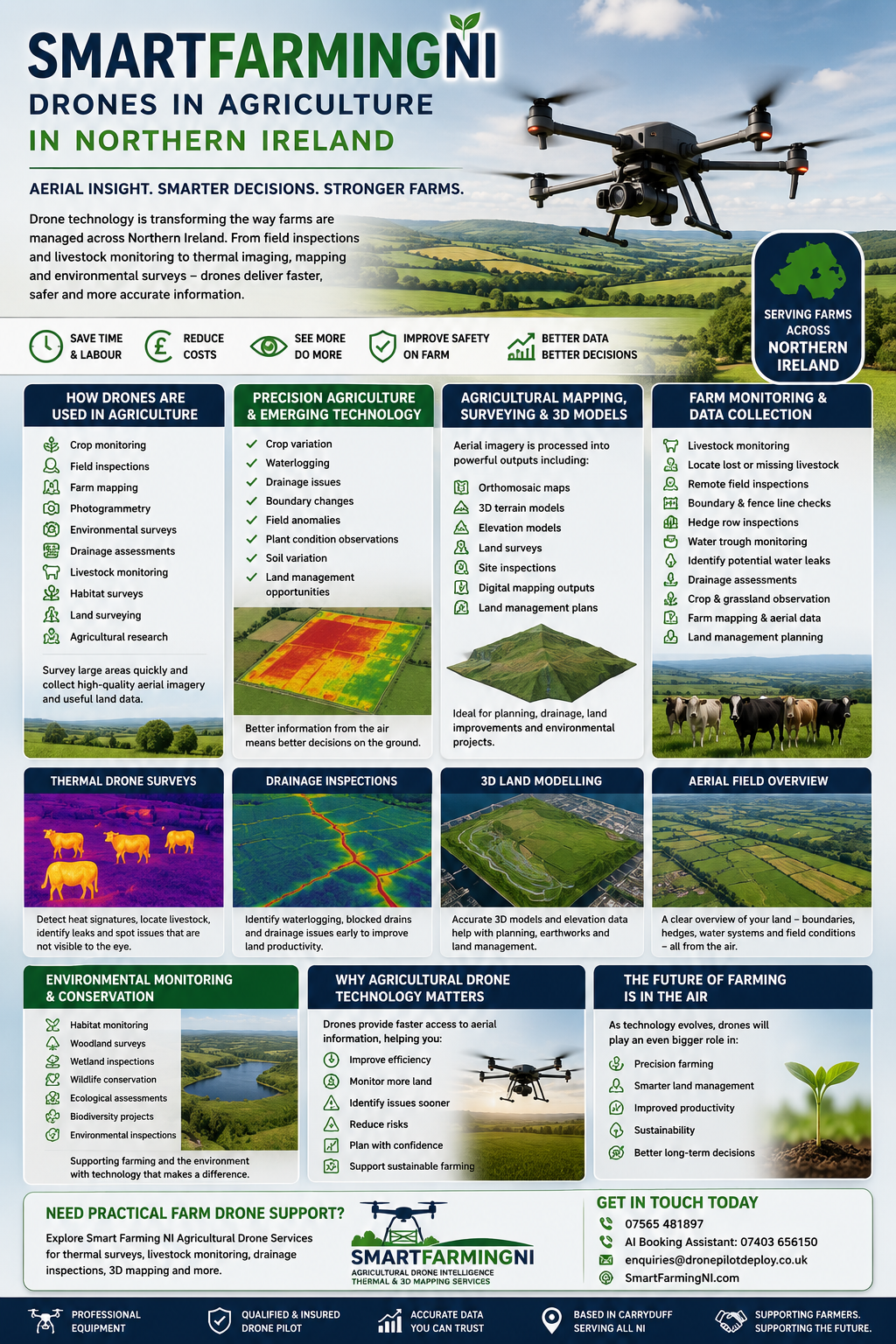
At Smart Farming NI, we provide practical drone services to support farm inspections, thermal land observations, livestock monitoring and aerial mapping.
Using drone technology, farms can gain a faster aerial overview of land conditions, helping identify visible changes, problem areas and wider field observations more efficiently.
Our focus is simple — providing practical aerial intelligence to help farmers better understand their land.
Our Agricultural Drone Services
Smart Farming NI currently provides:
- Thermal farm inspections
- Aerial drainage observations
- Livestock location and monitoring
- Missing livestock searches
- Boundary and fence inspections
- Hedge row inspections
- Water trough checks
- Farm mapping
- 3D land models
- Orthomosaic mapping
- General field inspections
- Land condition observations
These services help provide a clearer aerial overview of farmland, especially across larger areas.
Thermal Drone Inspections
Thermal drone technology can highlight temperature differences across farmland that may not be visible from ground level.
This can help support:
- Drainage pattern observations
- Waterlogged area identification
- Livestock location
- Heat anomaly observations
- General land inspections
Thermal surveys can provide useful aerial insight and support further ground inspection where needed.
Livestock Monitoring
Drone technology can help farmers monitor livestock across larger grazing areas.
This can support:
- Locating livestock
- Checking remote fields
- Monitoring movement
- Searching rough ground
- Thermal searches during low visibility
This can reduce time spent physically checking every field.
Farm Mapping and 3D Models
Smart Farming NI provides aerial mapping and 3D model generation to help visualise farmland from above.
Outputs can include:
- Orthomosaic maps
- 3D terrain models
- Elevation visuals
- Boundary overviews
- General aerial site views
These can be useful for understanding land layout, drainage routes and wider field conditions.
Boundary and Farm Infrastructure Inspections
Drone surveys can support quick inspections of:
- Fence lines
- Boundary edges
- Hedge rows
- Water troughs
- Access routes
- General farm infrastructure
This allows larger areas to be checked quickly without extensive walking.
Why Use Smart Farming NI?
Smart Farming NI provides practical drone support for farms across Northern Ireland.
Our drone services can help provide:
- Faster field overviews
- Thermal aerial observations
- Better visibility of land conditions
- Efficient livestock searches
- Practical aerial mapping
- Faster farm inspections
Whether you need a thermal inspection, livestock search, aerial mapping or a general farm overview, Smart Farming NI offers practical drone support tailored to your land.
Explore Our Agricultural Drone Services
If you would like to explore how drone technology could support your farm or land, visit our Smart Farming NI services page to learn more.
Smart Farming NI provides practical agricultural drone services across Northern Ireland, helping farmers and landowners gain a better aerial understanding of their land.
Visit our Smart Farming NI page today to make an enquiry.
The body content of your post goes here. To edit this text, click on it and delete this default text and start typing your own or paste your own from a different source.