Case Study: How Drone Technology could Transform Archaeology in Northern Ireland
Robert Dobbin • May 18, 2026
Introduction
Archaeology in Northern Ireland is undergoing a significant shift. As heritage teams, universities, and environmental researchers face increasing pressure to document, protect, and interpret historic landscapes, drone technology has emerged as one of the most valuable tools in modern archaeological practice.
From uncovering hidden earthworks to monitoring fragile coastal sites, drones are enabling archaeologists to work faster, safer, and with far greater accuracy than traditional ground‑based methods alone.
This case study explores how drone operations are reshaping archaeological workflows across Northern Ireland — and how Drone Pilot Training Academy is supporting this evolution.
Background: A Changing Landscape for Archaeology
Northern Ireland’s archaeological record is rich but vulnerable. Coastal erosion, agricultural activity, climate change, and natural degradation all pose risks to historic sites. Traditional surveying methods, while essential, can be time‑consuming, labour‑intensive, and limited by terrain.
Over the past five years, archaeologists across Ireland and the UK have increasingly turned to UAV (Uncrewed Aerial Vehicle) technology to enhance:
Site discovery
Excavation planning
Heritage documentation
Environmental and landscape archaeology
Long‑term monitoring
This shift mirrors global trends in digital heritage, where photogrammetry, LiDAR, and GIS are becoming standard tools for archaeological research.
The Challenge
Archaeological teams often face several constraints:
Limited access to remote or overgrown sites
Time‑sensitive excavations requiring rapid documentation
Fragile environments where footfall must be minimised
Need for accurate, repeatable data for research and preservation
Pressure to integrate digital workflows into heritage management
These challenges highlighted the need for a modern, scalable solution that could support both academic research and practical fieldwork.
The Drone‑Based Solution
Drone Pilot Training Academy worked with archaeologists, heritage groups, and university researchers to demonstrate how UAV technology can be integrated into archaeological workflows.
Using modern drone platforms equipped with advanced sensors, teams can now produce:
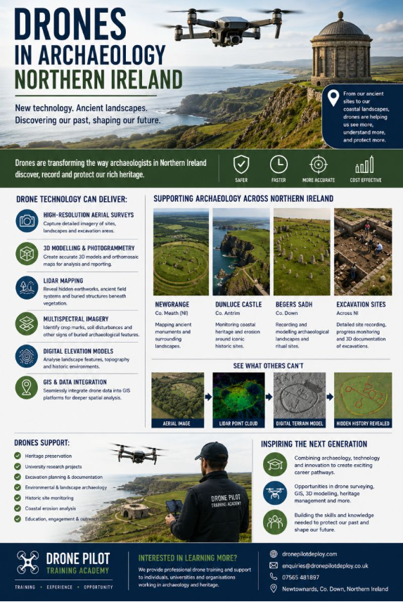
1. High‑Resolution Aerial Surveys
Capturing centimetre‑level detail across excavation sites, historic ruins, and landscapes.
2. 3D Photogrammetric Models
Providing accurate digital reconstructions for analysis, public engagement, and long‑term preservation.
3. Orthomosaic Mapping
Creating precise, georeferenced maps for excavation planning and documentation.
4. LiDAR Terrain Mapping
Revealing hidden archaeological features beneath vegetation — including earthworks, ditches, and ancient settlement patterns.
5. Multispectral Imaging
Identifying crop marks, soil disturbances, and buried structures invisible to the naked eye.
6. Digital Elevation Models (DEMs)
Supporting landscape archaeology, erosion studies, and heritage risk assessments.
Case Example: Supporting Archaeological Research in Northern Ireland
A recent collaboration involved supporting a university‑led archaeological project investigating early settlement patterns in a rural area of Northern Ireland.
Objectives
Map the surrounding landscape
Identify potential subsurface features
Document excavation progress
Produce digital models for academic analysis
Drone Workflow
Pre‑flight planning using GIS and historical maps
Aerial data capture using high‑resolution RGB and multispectral sensors
LiDAR scanning to penetrate vegetation cover
Processing into orthomosaics, DEMs, and 3D models
Integration with GIS for interpretation
Outcomes
Discovery of previously unrecorded linear earthworks
Identification of crop marks indicating potential settlement activity
Creation of a full digital twin of the excavation area
Improved communication with stakeholders and funding bodies
Enhanced student learning through digital archaeology techniques
The project demonstrated how drones can dramatically increase the speed, accuracy, and depth of archaeological research.
Impact on the Archaeology Sector
Across Northern Ireland and Ireland, drone technology is now supporting:
✔ Heritage preservation
✔ University and postgraduate research
✔ Excavation planning and documentation
✔ Environmental and landscape archaeology
✔ Coastal erosion monitoring
✔ GIS and digital mapping integration
The adoption of UAVs is also opening new career pathways for students in:
Archaeology
Geospatial surveying
Heritage management
Environmental science
Digital mapping and GIS
How Drone Pilot Training Academy Supports the Sector
Based near Belfast, Drone Pilot Training Academy provides:
A2 CofC and GVC training for archaeologists, researchers, and heritage professionals
Operational guidance for integrating drones into archaeological workflows
Industry‑focused training on photogrammetry, LiDAR, and data capture
Support for universities and research teams adopting UAV technology
Our mission is to help individuals and organisations understand how modern drone operations can support real‑world industries — including archaeology and heritage conservation.
Conclusion
As technology continues to evolve, the combination of archaeology, LiDAR, photogrammetry, GIS, and drone surveying will play an increasingly important role in protecting and understanding the past.
Northern Ireland is well‑positioned to lead in digital heritage innovation, and drone technology is now central to how we discover, record, and preserve our archaeological landscape.
Drone Pilot Training Academy remains committed to supporting this progress through professional training, operational expertise, and industry‑aligned education.
If you’re interested in how drone technology can support archaeology, heritage projects, environmental research, or academic study, we’d love to help. Visit Drone Pilot Training Academy to explore our professional A2 CofC and GVC training, industry‑focused drone courses, and specialist support for universities, heritage organisations, and research teams across Northern Ireland. Discover more at:www.dronepilottrainingacademy.com
The body content of your post goes here. To edit this text, click on it and delete this default text and start typing your own or paste your own from a different source.